
IV. Early History
The site of Fort Sheridan was located on an old trail between Green Bay, Wisconsin (established as a French trading post and mission ca. 1670) and the area that was to become Chicago. This trail was used by Native Americans traveling between their hunting grounds and villages in and around Chicago and trading posts in Wisconsin. Known as the Green Bay Trail, it extended north through Chicago along what is today North Clark Street. It stayed near the lake shore, and when it approached the area of Fort Sheridan, the trail skirted ravines to Highwood and continued north across the post’s rifle range. Although it was originally used by Native Americans, settlers who arrived in the area traveled the trail between trading posts. In order to facilitate safe passage for the early settlers along this thoroughfare, troops arrived to assist them so that the trail was also known as Military Road. After 1833, when the Potowattomi ceded all that remained of their land in Illinois to the United States (including Lake County and the land that is Fort Sheridan), trade expanded, causing increased traffic along the trail. The road that travels along much of the trail’s original route is known today as Green Bay Road.
A small community named St. Johns was settled in the 1840s. It was situated on a bluff overlooking Lake Michigan in the southeast corner of what was to be the site of the Fort, and south of what became the Historic District. Although the town, which was inaccessible by road, never became the shipping center its founders imagined, it contained logging, lumbering, leather tanning, brick making, iron casting, and a long pier that was used to ship lumber harvested on site.
The settlers who came to the area were mostly immigrants from Ireland, Germany, and the Scandinavian countries. They were predominantly self-sufficient people who toiled under difficult conditions and shipped their goods to Chicago. Because of the heavily forested land, the deep ravines, and the shoreline location, mid-century settlers never considered the present-day site of Fort Sheridan advantageous for farming. (The flat fertile prairie land west of the Fort, valued for its productivity, was more often selected by the settlers for their farmland.) At one time real estate speculators planned to make the area a summer haven for Chicago’s wealthy families. This plan was aban-doned after the depression of 1873.
By 1870, Chicago was a growing commercial center with a population of 300,000 and, because of its central location, viewed as the gateway to the west. It also served as home to the Division of the Missouri, an army division quartered there to protect the city’s residents. Commanded by the great Civil War General Philip H. Sheridan, the division was responsible for maintaining law and order in the frontier region.
General Sheridan’s expertise was needed almost immediately in Chicago. On October 8, 1871, the Great Chicago Fire destroyed 18,000 buildings and left thou-sands homeless. In the chaos that followed, looters and pillagers went on a rampage. To control the situation, Chicago Mayor Roswell B. Mason declared martial law and put General Sheridan in charge. Largely praised by Chicagoans for his tireless struggle to restore peace and order to the city, General Sheridan organized extensive relief efforts for the homeless and needy and called in infantry from the frontier to mitigate damages. Martial law was only temporary, however, and removed on October 23, 1871.
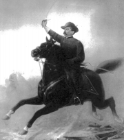
General Philip H. Sheridan.
Lake County (IL) Museum, Regional History Archives, 95.32
General Sheridan remained in Chicago until 1883, when he was reassigned to the War Department in Washington, D.C. By this time he had received the nation’s highest military office—Commanding General, United States Army.
Send any Fort-related news update information to mrtollfree@aol.com